User Files Search DCS
N'importe quelle version
F/A-18C Hornet
The most comprehensive guide for all your carrier launches and recoveries that could be fitted into kneeboard. Includes detailed overhead approach chart for landing ashore.
- Licence: Freeware - Version Gratuite, Distribution non limitée
- Langue: Anglais
- Taille: 6.24 Mo
- Téléchargé: 21193
- Commentaires: 44
N'importe quelle version
Autre
Your F10 map for when you can't use the F10 map. Includes Marianas WWII, Cold War Germany, Iraq, Afghanistan, Kola, Sinai, Normandy, South Atlantic, Mariana Islands, Syria, Persian Gulf, Nevada, The Channel, and Caucasus.
- Licence: Freeware - Version Gratuite, Distribution non limitée
- Langue: Anglais
- Taille: 87.67 Mo
- Téléchargé: 18936
- Commentaires: 149
N'importe quelle version
Autre
Cold War Germany Map; Standard Instrument Departure and Arrival kneeboards for Ramstein Air Base (ETAR / RMS). Magnetic headings adjusted for 4 degrees East Magvar; 1982. ILS / LOC approach for RWY 27 and RWY 09. Departure / Transition via Toley and Bolki.
- Licence: Freeware - Version Gratuite, Distribution non limitée
- Langue: Anglais
- Taille: 1.31 Mo
- Téléchargé: 300
- Commentaires: 1
N'importe quelle version
Autre
UPADTE: replace dcs-web-viewer-api-3.lua with the new dcs-web-viewer-api-4.lua !
Fixes occasional stutter some people experienced
Since I always had issues with the F10 map in VR, I've created an alternative for the F10 map.
* Works in 2D and VR, on any device with a browser ( PC, mac, tablet, phone )
* Show mission route points, distances, headings of your current mission
* Shows airport and beacon info on hover
* Show friendlies / neutrals / hostiles ( mission setting )
* Show / hide player position
* Follow player / show track
* Draw on map and take notes
* Import notes/drawings from DCS Web Viewer
* Open kml files
* Many different map styles including TPC, ONC, VFR & IFR HI/LOW
- Licence: Freeware - Version Gratuite, Ne Pas Redistribuer
- Langue: Anglais
- Taille: 16.38 Mo
- Téléchargé: 859
- Commentaires: 4
N'importe quelle version
Autre
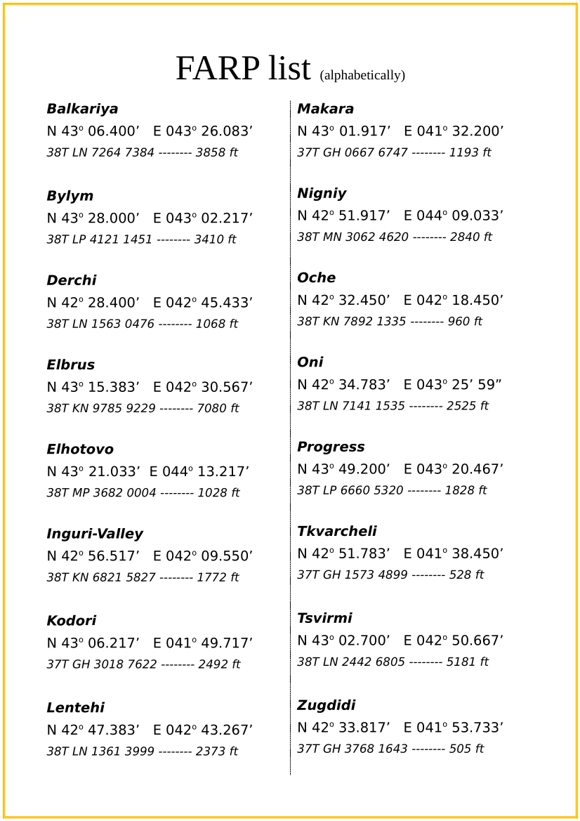
Charts with airfields, antennas and FARPs coordinates for "The Kaukasus Offensive" server.
- Licence: Freeware - Version Gratuite, Distribution non limitée
- Langue: Anglais
- Taille: 562.53 Ko
- Téléchargé: 110
- Commentaires: 0
N'importe quelle version
Autre
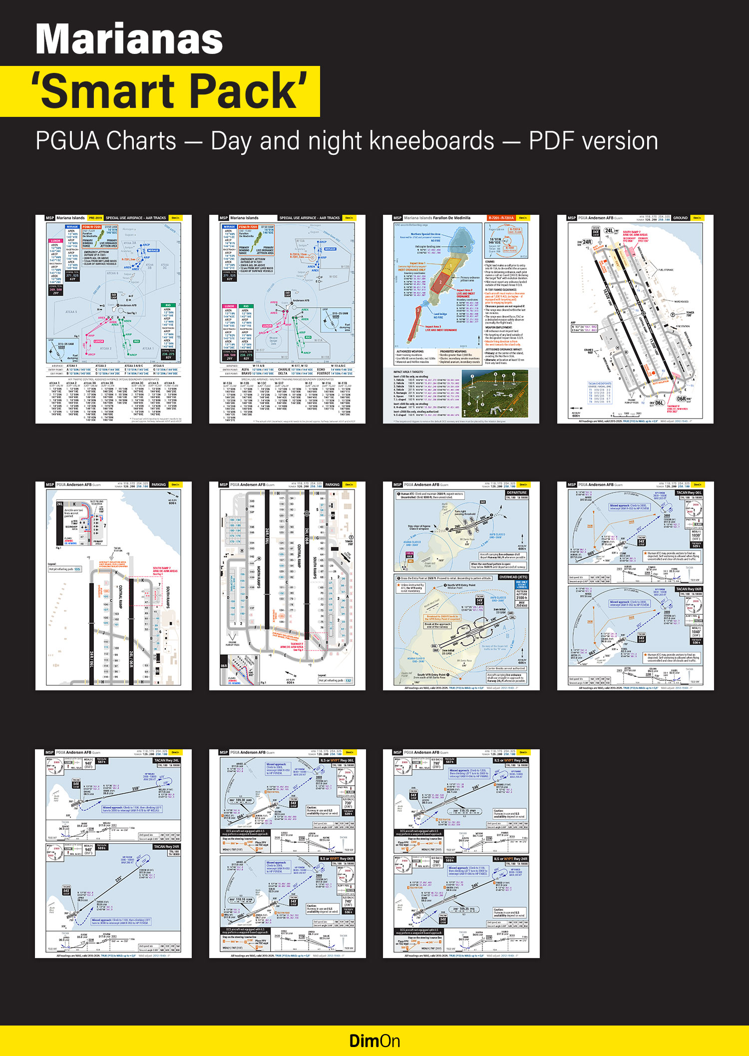
Everything you need to meaningfully fly and train on Mariana Islands. Includes the detailed charts of Andersen AFB (PGUA).
- Licence: Freeware - Version Gratuite, Distribution non limitée
- Langue: Anglais
- Taille: 17.67 Mo
- Téléchargé: 3346
- Commentaires: 13
N'importe quelle version
F/A-18C Hornet
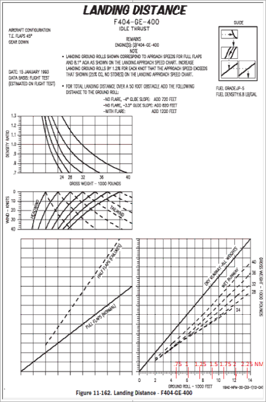
Kneeboards needed to compute your CG for proper takeoff, abort, rotate speeds, runway lengths needed, etc. Most are 'unnecessary' but I enjoy the added level of realism. The landing distance chart is more practical, for diverts, especially in the rain, for checking runway needed at current weight, in flight.
- Licence: Freeware - Version Gratuite, Distribution non limitée
- Langue: Anglais
- Taille: 2.25 Mo
- Téléchargé: 938
- Commentaires: 0


