


User Files Search DCS
DCS: World
Su-25T
This is a complete list of all airport/airfield/aerodrome IDs for use when flying the Su-25T. It has data for the following maps: Caucausus, Nevada/NTTR, Persian Gulf, and Syria. This is only a plain text file, feel free to do whatever you want with it.
These IDs were all found manually by spawning an Su-25T at every airport on the map, then checking the RTN or LNDG nav mode to show the airport ID in the HUD. I tried to make sure it was accurate, but no guarantees. I don't have the Normandy or Channel maps so if anyone would like to make a list of IDs and airport names for those and send them to me, I'll add them to this file.
See also this forum post: https://forums.eagle.ru/topic/261935-su-25t-airport-ids/
(I believe these IDs are also used by the Flaming Cliffs 3 planes, but they don't seem to show what waypoint number (or airfield ID) you have selected, so these IDs may not be much use for FC3.)
Additional keywords: navigation, airport, airfield, aerodrome, su-25
- Licencia: Gratuito - Versión gratuita, distribución libre
- Idioma: Inglés
- Tamaño: 1.16 Kb
- Descargado: 1010
- Comentarios: 0
DCS: World 2.0
A-10C Warthog
COMM/NAV CARDS for expanded NTTR region from recent DCS World 2.1.1 update. Replaces 2.0.4 version.
- Licencia: Gratuito - Versión gratuita, no distribuible
- Idioma: Inglés
- Tamaño: 710.2 Kb
- Descargado: 3452
- Comentarios: 2

DCS: World 1.5
M-2000C
This is a table in PDF format, with frequencies and coordinates of Caucasian map airports.realized for mirage 2000C. DCS 1.5
- Licencia: Gratuito - Versión gratuita, distribución libre
- Idioma: Inglés
- Tamaño: 18.4 Kb
- Descargado: 2314
- Comentarios: 0

Cualquier versión
Otro
With the arrival of 2.7, some like to carry out IFR approaches since the weather conditions are much more realistic and we can now have the chance to land our dear planes in shitty weather!
Airport approach charts based on reality and adapted to the DCS universe.
Approach headings, NDB, VOR, VORTAC, TACAN, ILS beacons, frequencies, heading, altitudes, GPS coordinates are checked and corrected to match the DCS universe!
I adapted the existing real approach maps to the game by adapting them (modified the paterns and the runway angles which are those of DCS) and they are readable in VR.
I also created maps for car parks and navigation routes.
I wish you all good use! Approach charts available for Syrian, Marianas, South Atlantic and Persian Gulf theaters !
- Licencia: Gratuito - Versión gratuita, no distribuible
- Idioma: Inglés
- Tamaño: 10.52 Mb
- Descargado: 1316
- Comentarios: 7

DCS World 2.7
Otro
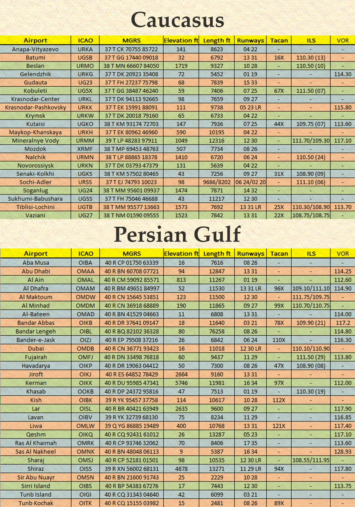
Military Grid Reference System coordinates for all airports on the Caucasus and Persian Gulf Maps
- Licencia: Gratuito - Versión gratuita, distribución libre
- Idioma: Inglés
- Tamaño: 2.53 Mb
- Descargado: 502
- Comentarios: 0

DCS World 2.7
Otro
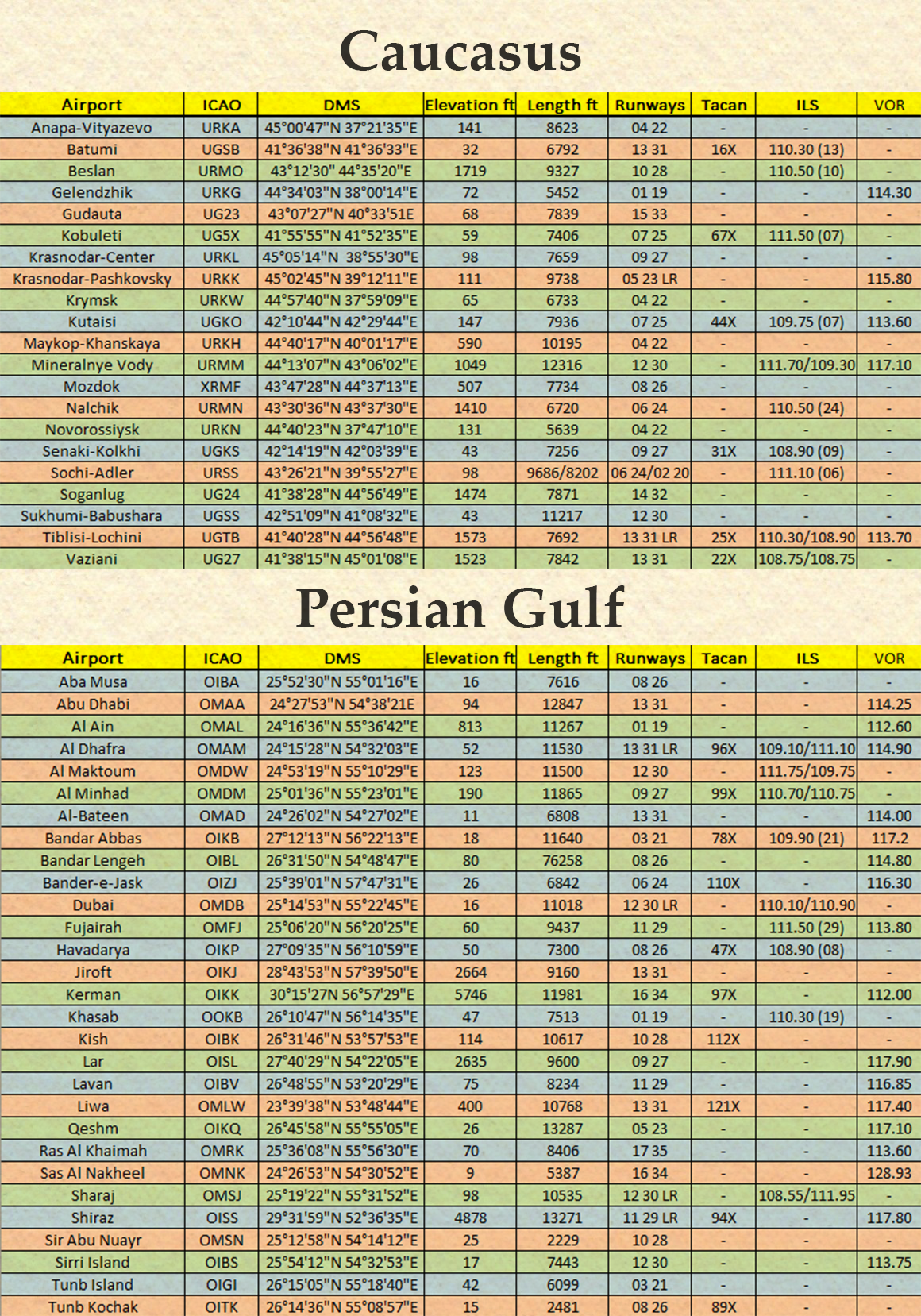
Degree-minute-seconds coordinates for all airports on the Caucasus and Persian Gulf Maps
- Licencia: Gratuito - Versión gratuita, distribución libre
- Idioma: Inglés
- Tamaño: 2.55 Mb
- Descargado: 513
- Comentarios: 0

DCS World 2.7
Otro
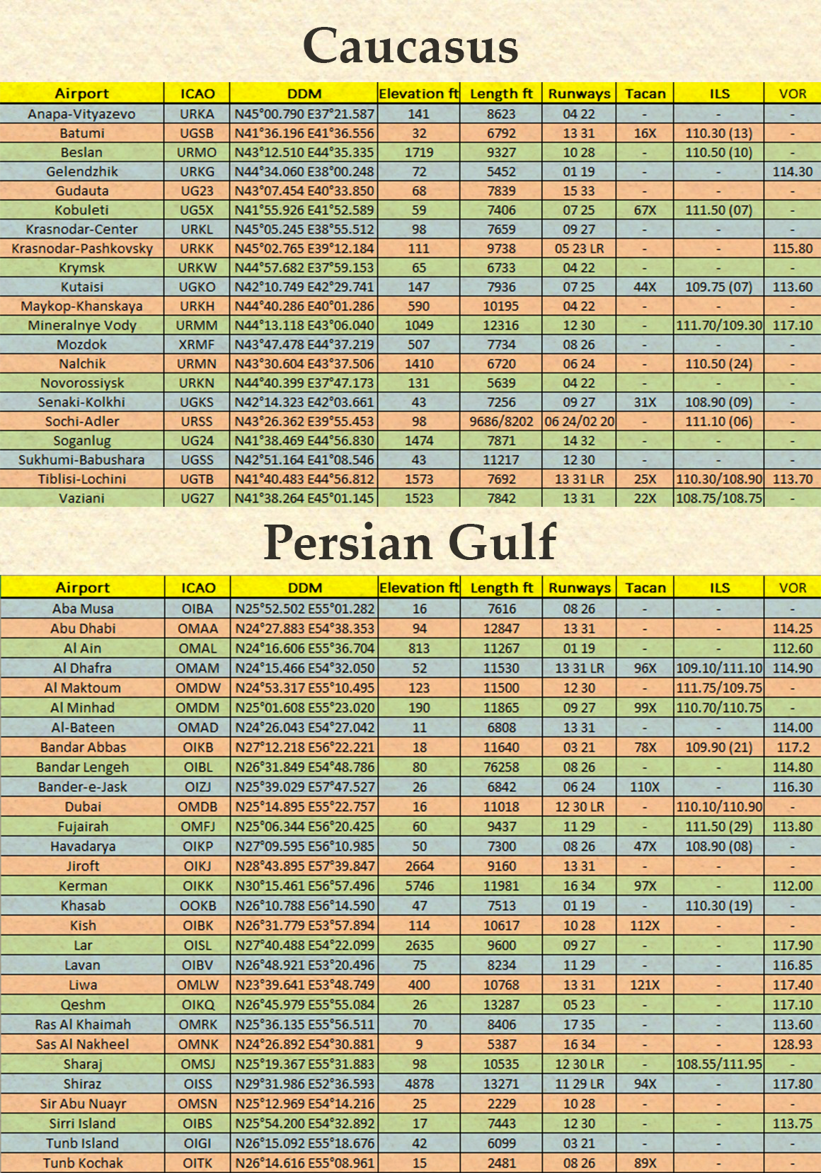
Degree-decimal-minutes coordinates for all airports on the Caucasus and Persian Gulf Maps
- Licencia: Gratuito - Versión gratuita, distribución libre
- Idioma: Inglés
- Tamaño: 2.56 Mb
- Descargado: 321
- Comentarios: 0
